SISTEMA DE REFERÊNCIA GEOCÊNTRICO PARA AS AMÉRICAS SIRGAS
|
|
|
- Julián Martínez Sosa
- hace 8 años
- Vistas:
Transcripción
1 IAG IPGH NIMA SISTEMA DE REFERÊNCIA GEOCÊNTRICO PARA AS AMÉRICAS SIRGAS BOLETIM INFORMATIVO N O 7 Dezembro de 2002

2 IAG IPGH NIMA EDITORIAL SUMÁRIO ATA DA REUNIÃO DO COMITÊ, OCORRIDA EM 21 E 21 DE OUTUBRO DE 2002, EM SANTIAGO DO CHILE ANEXOS DA ATA I: STATUS SOBRE A INTEGRAÇÃO DOS PAÍSES SUL-AMERICANOS AO SIRGAS (GT II DATUM GEOCÊNTRICO ) II: APRESENTAÇÃO DE RESULTADOS DA CAMPANHA GPS SIRGAS 2000 III: ITRFYY AND ITS GEODETIC APPLICATION, POR MUNEENDRA KUMAR APRESENTAÇÕES DO GT III DATUM VERTICAL IV: INTRODUÇÃO V: NECESSIDADE URGENTE DE UM SISTEMA DE REFERÊNCIA VERTICAL MODERNO VI: CÁLCULO DE NÚMEROS GEOPOTENCIAIS E ALTITUDES FÍSICAS VII: SUPERFÍCIE DE REFERÊNCIA: CONSIDERAÇÕES A RESPEITO DO W0 VIII: ATIVIDADES FUTURAS IX: ESTATUTO DO PROJETO SIRGAS X: LISTA DE PARTICIPANTES NA REUNIÃO DE SANTIAGO XI: FOTOS DA REUNIÃO Projeto SIRGAS Boletim Informativo N o 7 Pág. 1

3 IAG IPGH NIMA EDITORIAL Tenho o prazer de apresentar aos leitores a sétima edição do Boletim Informativo SIRGAS. Esta edição cobre integralmente a última reunião do projeto, realizada em 21 e 22 de outubro de 2002, em Santiago, Chile. Nesta reunião, importantes discussões e resoluções foram tomadas, descritas neste boletim, onde se destacam as relacionadas aos resultados da campanha GPS SIRGAS 2000 e ao novo estatuto do projeto. Gostaria de aproveitar a oportunidade para desejar aos leitores e colegas da comunidade SIRGAS e respectivos familiares um Feliz Natal e um Ano Novo de contínua paz, saúde e sucesso. Luiz Paulo Souto Fortes Presidente do Comitê SIRGAS Projeto SIRGAS Boletim Informativo N o 7 Pág. 2

4 IAG IPGH NIMA ATA DA REUNIÃO DO COMITÊ DURANTE O VII CONGRESSO INTERNACIONAL DE CIÊNCIAS DA TERRA, 21 E 22 DE OUTUBRO DE 2002, SANTIAGO, CHILE 21 de outubro 1. Abertura (L. Fortes, Presidente do Comitê) O presidente do Comitê destacou o apoio financeiro da Associação Internacional de Geodésia (IAG), decisivo para a realização da reunião. O Instituto Pan-americano de Geografia e História (IPGH), que tinha aprovado uma verba para o projeto em 2002, não pôde honrar este compromisso por estar enfrentando dificuldades financeiras. A IAG portanto atendeu ao nosso pedido de última hora, viabilizando a participação de oito participantes de sete países da América do Sul, fato que foi decisivo para o êxito da reunião. 2. Status sobre a integração dos países sul-americanos ao SIRGAS (R. Barriga, Presidente do GT II) (Anexo I) 3. Apresentação dos resultados da campanha GPS SIRGAS 2000 pelos centros de processamento 3.1 IBGE (S. Costa) (Anexo II) 3.2 DGFI (K. Kanniuth) As coordenadas obtidas pelas soluções individuais de cada centro de processamento (DGFI com Bernese, DGFI com GIPSY e IBGE com Bernese) apresentaram uma consistência entre si da ordem de 5 mm nas componentes horizontais e 7,5 mm na componente vertical. Resolução: O comitê SIRGAS decidiu que a solução final da campanha GPS SIRGAS 2000 será gerada pela combinação de três soluções: do DGFI, utilizando-se o software Bernese; do DGFI, utilizando-se o software GIPSY; e do IBGE, utilizando-se o software Bernese. 4. Combinação dos resultados dos centros de processamento (H. Drewes/K. Kanniuth/S. Costa) 4.1 Estratégia de combinação e conexão ao ITRF2000 M. Kumar, da NIMA, apresentou a questão de que as soluções ITRF são geradas usandose o modelo livre de marés, o que não é realístico, contrariando a resolução da IAG n 16 de 1983 (Anexo III) Projeto SIRGAS Boletim Informativo N o 7 Pág. 3

5 IAG IPGH NIMA Resolução: Seguir utilizando o modelo livre das marés nos resultados SIRGAS 2000 e sugerir formalmente à IAG que gestione junto ao International Earth Rotation Service (IERS) a solução da questão. 4.2 Determinação de velocidades Segundo H. Drewes, não se pode considerar apenas os resultados das campanhas SIRGAS 1995 e 2000 para se determinar as velocidades das estações SIRGAS. Resolução: O Comitê SIRGAS aprova a proposta de H. Drewes de se considerar as observações de estações GPS permanentes e das campanhas geodinâmicas, além dos resultados das campanhas SIRGAS 1995 e SIRGAS 2000, na determinação do campo de velocidades no continente sul-americano. 4.3 Resultados finais (coordenadas e velocidades) Resolução: O Comitê SIRGAS aceita antecipadamente como oficiais os resultados combinados finais da campanha GPS SIRGAS 2000, a serem gerados pelos centros de processamento em futuro próximo. Resolução: O Comitê SIRGAS define a data de 20 de dezembro de 2002 como limite para a apresentação dos resultados combinados finais da campanha GPS SIRGAS 2000 pelos centros de processamento. Resolução: O Comitê SIRGAS define a data de 28 de março de 2003 como limite para a apresentação, pelo DGFI, dos resultados do campo de velocidades para o continente sul-americano. Resolução: Os procedimentos para geração dos resultados oficiais da campanha GPS SIRGAS 2000 serão descritos em relatório final, à semelhança do divulgado por ocasião da Assembléia Científica da IAG realizada no Rio de Janeiro, em Resolução: O Comitê SIRGAS propõe a inclusão no relatório final da campanha GPS SIRGAS 2000 de um agradecimento especial aos centros de processamento DGFI e IBGE pelo enorme esforço despendido e pela excelência nos resultados alcançados. 5. Utilização dos resultados finais SIRGAS 2000 (H. Drewes, Representante da IAG) Resolução: O Comitê SIRGAS propõe a inclusão no relatório final da campanha GPS SIRGAS 2000 de instruções detalhadas de como utilizar os resultados finais da campanha. Projeto SIRGAS Boletim Informativo N o 7 Pág. 4

6 IAG IPGH NIMA Recomendou-se que, para os países que ainda não adotaram o SIRGAS 1995 como sistema de referência, que os mesmos adotem o sistema baseado nos resultados SIRGAS 2000, época de referência 2000,4. 6. Apresentação e início da discussão da proposta para o novo Estatuto (C. Brunini, Representante Substituto da Argentina) 22 de outubro 7. Apresentações do Grupo de Trabalho III Datum Vertical (L. Sanchez, Presidente do GT III, e H. Drewes, Representante da IAG) 7.1 Introdução (Anexo IV) 7.2 Necessidade urgente de um sistema de referência vertical moderno (Anexo V) 7.3 Cálculo de números geopotenciais e altitudes físicas (Anexo VI) 7.4 Superfície de referência: considerações a respeito do W0 (Anexo VII) 7.5 Atividades futuras (Anexo VIII), recomendando-se aos países: Nivelación geométrica de las estaciones SIRGAS2000 Conexión de las redes de nivelación entre países vecinos Identificación y digitación de todas las líneas de nivelación que conectan las estaciones SIRGAS2000 Digitación de las redes de nvelación nacionales Identificación de los nodos en las redes Determinación UNIFICADA del cuasi-geoide Determinación de la topografía de la superficie del mar (SSTop) (posicionamiento GPS de los mareógrafos) A presidente do GT III ofereceu apoio aos países membros do Comitê SIRGAS para calcular os números geopotenciais e ajudar em tarefas paralelas. Ressalta-se que os desníveis a serem utilizados nos cálculos são os observados, SEM distribuição de erros ou ajustes. 8. Continuação da discussão da proposta para o novo Estatuto (L. Fortes e C. Brunini) Resolução: O Comitê SIRGAS aprova o novo Estatuto do projeto, correspondendo à versão originalmente proposta pela representação da Argentina, com as modificações discutidas durante a reunião de Santiago do Chile. Com a aprovação do Estatuto (Anexo IX), o Representante Substituto da Argentina no Comitê, Claudio Brunini, propôs os nomes de Luiz Paulo Souto Fortes, do IBGE/Brasil, e de Eduardo Andrés Lauría, do IGM/Argentina, respectivamente para presidente e vicepresidente do projeto para o próximo termo ( ). O presidente atual do Comitê SIRGAS irá contactar todos os países abrangidos pelo projeto de forma a confirmar os nomes dos representantes no Comitê e, consequentemente, definir o quorum necessário para se eleger as novas autoridades do projeto. Esta eleição será conduzida por correio Projeto SIRGAS Boletim Informativo N o 7 Pág. 5
 7.3 Cálculo de números geopotenciais e altitudes físicas (Anexo VI) 7.")
7 IAG IPGH NIMA eletrônico e as autoridades eleitas serão empossadas em julho de 2003, por ocasião da Assembléia Geral da Associação Internacional de Geodésia. 9. Encerramento (L. Fortes) Resolução: O Comitê SIRGAS agradece ao Instituto Geográfico Militar do Chile pela excelente organização da reunião e pelo apoio aos membros do Comitê. 10. Lista de participantes (Anexo X) 11. Fotos da reunião (Anexo XI) Projeto SIRGAS Boletim Informativo N o 7 Pág. 6
 11.")
8 IAG IPGH NIMA ANEXO I STATUS SOBRE A INTEGRAÇÃO DOS PAÍSES SUL-AMERICANOS AO SIRGAS (GT II DATUM GEOCÊNTRICO ) (incluído na versão completa deste Boletim, disponível em

9 GRUPO DE TRABAJO II DATUM GEOCENTRICO TCL. R. Barriga V. rbarriga@igm.cl

10 GRUPO DE TRABAJO II DATUM GEOCENTRICO MISION : Establecer un Datum Geocéntrico mediante la extensión de la Red GPS SIRGAS a través de la integración de las Redes Geodésicas de cada uno de los países sudamericanos participantes en el Proyecto. SITUACION INDIVIDUAL DE CADA PAIS

11 RESPONSABLES ARGENTINA : Claudio Brunini, Juan Moirano U. Nac. De la Plata. Rubén Rodríguez Eduardo Lauría, Instituto Geográfico Militar. MEDICIONES DE TERRENO : 136 estaciones Red POSGAR puntos en común con POSGAR 94 PROCES. DE LOS DATOS AVANCE CONTRIBUCION A SIRGAS 2000 : Universidad Nacional de la Plata - DGFI. Software BERNESE 3.5 : Recientemente el Subcomité de Geodesia ha recomendado el uso del nuevo marco de referencia POSGAR 98 para las aplicaciones geodésicas de alta precisión que se desarrollen en el futuro, aunque mantendrá por un tiempo más la vigencia de POSGAR 94. POSGAR 98, época : 20 estaciones.

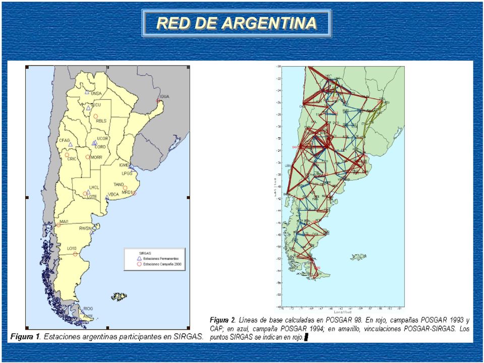
12 RED DE ARGENTINA
13 BOLIVIA SIN ANTECEDENTES ACTUALES RESPONSABLES MEDICIONES DE TERRENO PROCES. DE LOS DATOS CONTRIBUCION A SIRGAS 2000 : Instituto Geográfico Militar : Existen 2 Redes de control GPS - Red geodésica Fundamental clase A - Red Minera clase B. : Instituto Geográfico Militar - UNLP Software BERNESE. : 9 estaciones..

14 ECUADOR RESPONSABLES : Departamento de Geodesia del instituto Geográfico Militar MEDICIONES DE TERRENO : 135 estaciones medidas durante 1994, 1996 y PROCES. DE LOS DATOS : En DGFI, Munich, Software BERNESE 4.0. AVANCE CONTRIBUCION A SIRGAS 2000 PUNTOS AMBOS SISTEMAS : Obtención de coordenadas enlazadas a SIRGAS, época : 8 estaciones. : 42 puntos en común entre PSAD56 y SIRGAS para la determinación de parámetros locales de transformación...

15 RED DEL ECUADOR

16 BRASIL RESPONSABLES CONTRIBUCION A SIRGAS : Sonia María Alves Costa - IBGE Instituto Brasileiro de Geografía y Estadística. : 22 estaciones SIRGAS, 14 son de la Red de Monitoreo Contínuo. PROCES. DE LOS DATOS : IBGE, Software BERNESE 4.0. AVANCE : En Octubre del año 2000 el IBGE organizó y coordinó el primer Seminario para visualizar la adopción de el nuevo Marco de Referencia Geodésico. En el año 2005, Brasil pretende adoptar el SIRGAS oficialmente. CONTRIBUCION A SIRGAS 2000 : 21 estaciones.

17 RED DEL BRASIL 5 0 Rede Nacional GPS ano Manaus Imperatriz Fortaleza Crato Recife Cuiaba Brasília BomJesus Salvador P.Prudente Curitiba Viçosa R.Janeiro -30 GPS SIRGAS/RBMC Sta. Maria Porto Alegre

18 CHILE RESPONSABLES MEDICIONES DE TERRENO PROCES. DE LOS DATOS AVANCE CONTRIBUCION A SIRGAS 2000 : Instituto Geográfico Militar. : 260 puntos Nueva Red Geodésica Nacional. 133 puntos conectados a la antigua Red. : Instituto Geográfico Militar Software BERNESE 4.0 : Coordenadas preliminares ITRF 2000, a la espera de ajuste final a SIRGAS Se estima que en el año 2005 se adoptará oficialmente SIRGAS en Chile. : 20 estaciones, incluyendo 8 estaciones GPS permanentes y 5 mareógrafos.

19 RED CHILENA

20 COLOMBIA RESPONSABLES MEDICIONES DE TERRENO PROCES. DE LOS DATOS AVANCE CONTRIBUCION A SIRGAS 2000 : Laura Sánchez Instituto Geográfico Agustín Codazzi. : La Red MAGNA consta de 60 estaciones GPS de las cuales 16 corresponden a la Red CASA (Red Geodinámica para Centro y Sur de América). : I. G. Agustín Codazzi - DGFI. Software BERNESE 4.0 : La Red MAGNA y en consecuencia SIRGAS fue adoptado como sistema oficial en Colombia desde Se están definiendo los estándares de geoposicionamiento a nivel nacional, dentro de la normativa ISO9001. : 8 estaciones.

21 RED DE COLOMBIA PTBOL NAZAR 11 SANAN SMART BQUIL RIOHA MAICA 10 SAN ANDRES, PROVIDENCIA Y SANTA CATALINA CARTA PLATO BOSCO VALLED 9 8 COROZ MOMPO SROQU MONTE TIBU TURBO AGUAC CAUCA CUCUT 7 YARUM BUCAR SARAV ARAUC 6 5 SOLAN QUIBD PTBER RIONE TUNJA GUARI MANIZ BOGOT YOPAL OROCU CRNOR PTCAR 4 MALPELO TULUA BTURA IBAGE VILLA PTINI 3 CALI NEIVA BACOM GUAPI POPAY SJGUA 2 1 TUMAC PASTO IPIAL FLORE MOCOA MITU SFELI 0 PTLEG ARARA 1 CHORR PEDRE LETIC
22 PARAGUAY SIN ANTECEDENTES ACTUALES RESPONSABLES MEDICIONES DE TERRENO PROCES. DE LOS DATOS CONTRIBUCION A SIRGAS 2000 : Servicio Geográfico Militar : 165 puntos medidos de la Red Geodésica primaria en : Servicio Geográfico Militar y por el NIMA. : 1 Estación.
23 PERU SIN ANTECEDENTES ACTUALES RESPONSABLES MEDICIONES DE TERRENO PROCES. DE LOS DATOS CONTRIBUCION A SIRGAS 2000 : Instituto Geográfico Nacional : 165 puntos medidos de la Red Geodésica primaria en : Servicio Geográfico Militar y por el NIMA. : 10 estaciones.
24 URUGUAY SIN ANTECEDENTES ACTUALES RESPONSABLES CONTRIBUCION A SIRGAS 2000 : Servicio Geográfico Nacional y el Instituto de Agrimensura. : 8 estaciones.
25 VENEZUELA RESPONSABLES : José Napoleón Hernández Instituto Geográfico de Venezuela Simón Bolivar MEDICIONES DE TERRENO : 156 estaciones entre 1995 y PROCES. DE LOS DATOS AVANCE CONTRIBUCION A SIRGAS 2000 : Software BERNESE : Venezuela posee 210 vértices integrados a SIRGAS, disponibles y publicados. Así mismo se encuentran 500 vértices totalmente calculados, en fase de edición de descripciones, accesos y monografías. Venezuela oficialmente ha adoptado a SIRGAS como nuevo Sistema de Referencia. : 11 estaciones.
26 RED DE VENEZUELA
27 IAG IPGH NIMA ANEXO II APRESENTAÇÃO DE RESULTADOS DA CAMPANHA GPS SIRGAS 2000 (incluído na versão completa deste Boletim, disponível em
28 RESULTS OF THE SIRGAS 2000 GPS CAMPAIGN Klaus Kaniuth - Deutsches Geodatisches Forschungsinstitut - DGFI Sonia Costa - Brazilian Institute of Geography and Statistics - IBGE International Symposium of the IAG Recent Crustal Deformation in South America and Surrounding Area, october, 2002
29 RESULTS OF THE SIRGAS 2000 GPS CAMPAIGN 2 Goals of SIRGAS2000 campaign Maintenance of SIRGAS reference frame; Define a unique height reference system for the Americas.
30 RESULTS OF THE SIRGAS 2000 GPS CAMPAIGN 3 Selection criteria of stations Tide gauges, which define the vertical datum of the leveling networks in each country; Other tide gauges (countries with long extension of coast); Stations of leveling networks at the borders between neighboring countries; Stations participating of SIRGAS95 network.
31 RESULTS OF THE SIRGAS 2000 GPS CAMPAIGN 4 Campaign Specifications and Equipment The data on each station was organized in 24 hours period and converted to RINEX format; Data collection rate was 15 and 30 (IGS and NGS) sec. ; Double frequencies receivers preferably with choke ring antenna or receivers without choke ring antenna, that ones recognized by IGS; Station information's: station name, observation sessions, antenna height (slant/vertical) and antenna/receiver type (IGS identification).
32 RESULTS OF THE SIRGAS 2000 GPS CAMPAIGN 5 Processing Information's Orbits and ERP: Combined IGS (SP3 files); Coordinates of the reference stations : ITRF97, epoch ; Antenna phase center offset and variation: Information obtained at IGS and NGS; Antenna heights were corrected to ARP (Antenna Reference Point). Software: Bernese, version 4.2
33 RESULTS OF THE SIRGAS 2000 GPS CAMPAIGN Processing Strategies - IBGE Solutions Options Mode Daily sessions Observations double differences, observable L3 (ionosphere free, linear combination of L1 and L2) Strategy forming OBS-MAX baselines Sampling rate 30 sec. Elevation cut off angle 10 degrees Elevation weighting Cos(z) Troposphere model (A Not applied PRIORI) Trop. zenith delay Every 2 hours (12 corrections) Mapping function Niell (dry component) Ionosfere model Not applied Ambiguity resolution QIF (Quasi Ionosfere Free) + GIMs\CODE maps Ocean Loading Not applied Reference Stations AREQ, AMC2, ALBH, AOML, BRAZ, CRO1, FORT, LPGS, OHIG, KOUR, SANT, WES2, CORD, JAMA and UNSA 6
34 RESULTS OF THE SIRGAS 2000 GPS CAMPAIGN Combination of Solutions / IBGE Divided in 9 blocks, with about 22 stations each; 3 IGS stations make the link between blocks; Final daily solutions were saved as removable constraints 7
35 RESULTS OF THE SIRGAS 2000 GPS CAMPAIGN 8 Link Stations between blocks N N1 N2 C S S1 S2 S3 S4 WES2 WES2 AOML JAMA CART BOGA BRAZ UNSA LPGS AMC2 AMC2 INEG CRO1 FORT IMPZ ZAMO LPGS SANT ALBH ALBH BRMU ESTI KOUR BRAZ UNSA CHAM CORD BRMU JAMA CART BOGA AREQ LPGS CORU AOML CRO1 FORT IMPZ ZAMO CHAM SANT INEG ESTI KOUR BRAZ UNSA CORU CORD
36 RESULTS OF THE SIRGAS 2000 GPS CAMPAIGN Network Configuration and Blocks Division - IBGE -
37 RESULTS OF THE SIRGAS 2000 GPS CAMPAIGN STATIONS PROBLEMS AND CHANGES UCOR (Argentina) and NPAC (Guatemala) were not used in processing. CART (Colombia) is a different station from campaign 1995, but has the same identification for SIRGAS2000. BATL (Ecuador) was identified as GALA (Ecuador) in campaign Consequently, GALA in campaign 2000 (IGS station) is a different station from campaign MANU (Brazil) station was identified as MANA in campaign L10B (Argentina) was identified as LO10 in campaign CACH (Brazil) station from campaign 1995 was destroyed and changed to CAC1. BOGT (Colombia) station in 1995 campaign, was changed to BOGA. Stations YACA (Uruguay), ASUN (Paraguay), were not occupied in SIRGAS 2000 campaign. 10
38 RESULTS OF THE SIRGAS 2000 GPS CAMPAIGN DATA PROBLEMS Too many cycles slips: VIMS (U.S.)/day 133, YBHB (U.S.)/day 134, TEGU (Honduras)/ day131, CHIQ (Bolivia)/ days Few quantity of data: KAMA (Venezuela)/day132 (4 hours of data), ARIC/day 135 (1:30 of data), LOTE (Argentina)/day 136 one hour of data), RIOP (Ecuador)/day 134 (some minutes of data), NPRI (U.S.)/day 132 (less than 6 hours of data), AMC2 (U.S.)/day 137 (less than 6 hours of data), CA00/day 137. Data from wrong date: MERI (Mexico)/day 138 (data from 1980), CHI3 (Mexico)/day 135, OAXA (Mexico)/day 135, RBLS (Argentina)/day 139. Data excluded because of observations problems: ANTF (Chile)/days 136, 137, 138, 139 and
39 RESULTS OF THE SIRGAS 2000 GPS CAMPAIGN Results Preliminary combination: ADDNEQ removable constraints: CRO1, KOUR, FORT, ALBH, WES2, BRAZ, AREQ, LPGS, SANT, OHIG and CORD. Stations excluded from final results: UCOR, NPAC and ANTO. Number of stations processed = 182 Stations with less than 5 days of solutions: CHAJ (3 days), JUNQ (3 days), LOTE (4 days), ELEN (2 day) and RIOP (3 days). Checking accuracy with ITRF2000: Stations, which have residuals higher than 20 mm are: GALA, CRO1, INEG, SIO3. 12
40 RESULTS OF THE SIRGAS 2000 GPS CAMPAIGN RESULTS OF THE SIRGAS 2000 GPS CAMPAIGN Accuracy of solution / IBGE ITRF2000 RESIDUALS NORTH EAST UP 10 0 ALBH ALGO AMC2 AOML AREQ ASHV BOMJ BRAZ BRMU CHA1 CHUR CORD CRO1 CUIB DRAO DUBO EISL FLIN FORT GAL1 GALA GODE HOLB IGM0 MM STATIONS ITRF2000 RESIDUALS NORTH EAST UP 20 0 IMPZ INEG JAMA KOUR LPGS MANU OHIG PARA PUR3 RIOG RIOP SANT SCH2 SIO3 SOL1 STJO UEPP USNA USNO VBCA VICO VIMS WES2 WHIT WILL YELL MM STATIONS
41 RESULTS OF THE SIRGAS 2000 GPS CAMPAIGN 14 Consistency of daily solutions / IBGE The stations, which have up component RMS higher than 20 mm are: IMPZ and TALA EISL station presented higher RMS in the internal solution
42 RESULTS OF THE SIRGAS 2000 GPS CAMPAIGN Consistency of Block solutions milimeter milimeters milimeters UNWEIGHTED RM S RESIDUALS - NORTH COM PONENT DAYS UNWEIGHTED RMS RESIDUALS - EAST COMPONENT DAYS DAYS UNWEIGHTED RMS RESIDUALS - UP COMPONENT SIRGASN SIRGASN1 SIRGASN2 SIRGASC SIRGASS SIRGASS1 SIRGASS2 SIRGASS3 SIRGASS4 SIRGASN SIRGASN1 SIRGASN2 SIRGASC SIRGASS SIRGASS1 SIRGASS2 SIRGASS3 SIRGASS4 SIRGASN SIRGASN1 SIRGASN2 SIRGASC SIRGASS SIRGASS1 SIRGASS2 SIRGASS3 15 SIRGASS4
43 RESULTS OF THE SIRGAS 2000 GPS CAMPAIGN Consistency of Block solutions milimeter milimeter DAYS DAYS WEIGHTED RM S RESIDUALS - NORTH COM PONENT WEIGHTED RMS RESIDUALS - EAST COMPONENT SIRGASN SIRGASN1 SIRGASN2 SIRGASC SIRGASS SIRGASS1 SIRGASS2 SIRGASS3 SIRGASS4 SIRGASN SIRGASN1 SIRGASN2 SIRGASC SIRGASS SIRGASS1 SIRGASS2 SIRGASS3 SIRGASS4 milimeters DAYS WEIGHTED RMS RESIDUALS - UP COMPONENT SIRGASN SIRGASN1 SIRGASN2 SIRGASC SIRGASS SIRGASS1 SIRGASS2 SIRGASS3 SIRGASS4 16
44 IAG IPGH NIMA ANEXO III ITRFYY AND ITS GEODETIC APPLICATION POR MUNEENDRA KUMAR
45 ITRFyy AND ITS GEODETIC APPLICATION By Muneendra Kumar National Imagery and Mapping Agency Bethesda MD (USA) Abstract The International Terrestrial Reference Frame (ITRF) is a realization of the International Terrestrial Reference System (ITRS). Since its first realization in 1988, there have been many variations and additions in data types and changes in computations of ITRF. Between ITRF88 and ITRF97, the reference epochs have also changed three times. Many technical notes from the International Earth Rotation Service (IERS) are available. These notes explain and provide in great details all the technical complexities of different realizations, which have been update every year between 1988 and After 1994, the ITRF 96 and 97 are the two latest solutions. This paper intends to present and clarify the technical interpretation of the ITRF realization and its definition for the practical geodesists who want to update the geodetic infrastructure of a nation, region, continent, or for the world. The attempt here is to include significant details and explanations to provide a clear and consistent interpretation. 1. INTRODUCTION International Earth Rotation Service (IERS), since it s founding in 1988, has been updating ITRS with its realizations as ITRF. First solution was ITRF88, which then was followed yearly by ITRF89, 90, 91, 92, 93, and 94. After this, we got two more solutions, viz., ITRF96 and ITRF97. ITRF realization consists in a set of station Cartesian coordinates, a velocity field, and a full variance-covariance matrix (Silard et al, 1998). The direction of the IERS Reference Pole (IRP) and Reference Meridian (IRM) corresponds to the Bureau International de L Heure (BIH) Conventional Terrestrial System (CTS) Pole and Zero Meridian (McCarthy, 1996). Between 1988 and 1993, ITRFyy (where yy corresponds to the year in which it was realized) solution was obtained by a combination of all data submitted to the beginning of yy+1 (Boucher et al, 1997). Here, the reference epoch was The ITRF94 was then defined to the reference epoch Then, the reference frame definition (origin, scale, orientation, and time evolution) was achieved in such a way that ITRF96 is in the same system as ITRF94 (Boucher et al, 1997). This was followed by a combined solution for ITRF96 and ITRF97 with as reference epoch. This paper provides and clarifies the technical details concerning the different ITRFs and their reference epochs with the each periodic IERS solution. A suggested approach is also included for geodetic use when updating national, regional, continental, and/or global geodetic system(s) or datum(s). Published in the Proceedings of the IAG 2001 Scientific Assembly, 2-7 September 2001, Budapest, Hungary
46 2. INTERNATIONAL TERRESTRIAL REFERENCE FRAME (ITRF) ITRF is a realization of the International Terrestrial Reference System (ITRS). The orientation of its axes is consistent with the Bureau de L Heure (BIH) Conventional Terrestrial System (CTS) at the epoch , in accordance with the resolution of the International Union of Geodesy and Geophysics (IUGG) and International Astronomical Union (IAU). The orientation of the system is such that it has no residual rotational horizontal velocity relative to the Earth s crust. The construction of the ITRF is based on the combination of sets of station coordinates and velocities derived from observations from Very Long Baseline Interferometry (VLBI), Satellite Laser Ranging (SLR), and Lunar Laser Ranging (LLR). Data from Global Positioning System (GPS) was introduced in 1991 and from Doppler Orbitography and Radio-positioning Integrated by Satellite (DORIS) in ITRFyy represents a solution, which is based on the data sets that are available till the end of year yy and is performed in the year yy+1. From the first ITRF88 the solutions are available for 89, 90, 91, 92, 93, 94, 96, 97, and a combined solution for 96 and ITRF COMPUTATIONS The procedure is in sequential steps. (1) First step involves a reduction of coordinates for the participating stations to a common reference epoch t 0 using their respective velocity models. These velocity models are either based on fixed tectonic plate motion or estimated velocity fields. The computations (X S, X S ) t0 are done separately for each system S, e.g., VLBI. (2) Second step involves a least-squares estimation at the reference epoch t 0 the coordinates and velocities for the ITRFyy of all the stations from all the systems, e.g., VLBI, SLR, LLR, GPS, and DORIS. The model used in the combination solution is based on Euclidian similarity of seven parameters: X S X T 1 S Y S = Y + T 2 S D S + R 3 S -R 3 S D S S R 2 S R 1 X Y (1) Z S Z t 0 T 3 S R 2 S R 1 S D S Z t 0 where X,Y,Z are the coordinates of a station at reference epoch t 0 in the ITRFyy, T 1S, T 2S, T 3S, D S S, R 1S, R 2S, R 3 are respectively the three translations, scale factor, and three rotations between the ITRFyy and individual S solutions. (3) The local geodetic survey ties, with their standard deviations, are used to tie the stations of the different systems.
47 4. ITRF EPOCHS From the first ITRF88, the reference epochs used to define different ITRF solutions (Altamimi, 2000) are: ITRF88 to ITRF ITRF ITRF ITRF96 and ITRF ITRF Here, we can interpret that ITRF 89 to ITRF93 represent the realization of ITRF88 with additional data sets in each subsequent solution. Thus, in real sense, each of the solutions for the years 1988 to 1993 only realized the same ITRF. It is important to note that the combined solution for the ITRF96 and ITRF97 was obtained by combining positions and velocities simultaneously. This procedure allowed the use of full variance-covariance matrices of the individual VLBI, SLR, GPS, and DORIS data solutions. This will allow users to propagate the positions to any desired epoch. Thus, this approach also replaced the old ITRF96 as a separate realization. 5. ITRF DEFINITION Coordinates are defined in a conventional tide-free system (APPENDIX 1) where effects of all tidal have been removed. To achieve this, the Equation 6 (Pp. 57, IERS Tech Note 21, 1996) is used. 6. ITRF ORIENTATION AND SCALE (1) The orientation is defined by adopting IERS Earth Orientation Parameters (ERP) at a reference epoch (See Section 3). (2) The orientation of the IERS Reference Pole (IRP) and Reference Meridian (IRM) were initially given by the BIH Terrestrial System (BTS) (McCarthy, 1996). Subsequently, the IRP and IRM are consistent with the corresponding directions of the BTS within Thus, the corresponding BTS for the ITRF solutions from 1988 to 1993 (Section 4) will then be: ITRF88 to ITRF93 - BTS Since BIH was replaced by IERS from 1988, the orientations for ITRF94, ITRF96, and ITRF97 followed an independent definition. According to Montag (1997), the IRP and IRM were defined by IERS on the basis of the Conventional International Origin (CIO). However, it is not clear which CIO would have been used.
48 (3) The scale is obtained by relativistic modeling and is consistent with the Geocentric Coordinate Time (TCG) for a geocentric local frame (Chapter 11, IERS Tech. Note 21, 1996). (4) The unit is meter (SI). The time evolution of the orientation is maintained by using a no-net- rotation condition with regards to the horizontal tectonic motions over the whole Earth. 7. MOVEMENT OF THE GEOCENTER Recent analysis of SLR and other satellite data has shown that the coordinates of stations connected to the solid Earth, as realized by the ITRF, show variations as compared with the ITRF, which is assumed to be fixed to the rigid Easrth s crust (Montag, 1997). Thus, the origin of the ITRF is defined such that the time-dependent translation vector T (from the ITRF origin to the instantaneous center of mass of the Earth) is minimum (Montag, 1997). 8. GEODETIC APPLICATION A. Important Considerations (McCarthy, 1996) - a. ITRF coordinates are realized in the tide-free system and it is important to note that this system is not realistic and the crust can not be observed. b. Alternatively, in the zero-tide system, the crust corresponds to the realistic time average which varies because of the action of lunisolar tides. c. The ITRF coordinates (Section 8.A.a. above) contradicts the IAG Resolution 16, adopted at The 1983 General Assembly (APPENDIX 2). B. Recommendation - The following steps relate to a 10-day GPS campaign scenario which is observed from 25 June to 5 July 2001, with mid-epoch of a. Select the IGS stations, which are to be used as constraints to define the intended geodetic system. b. Using the latest available ITRF coordinates and velocities, viz., ITRF00 with reference epoch , propagate coordinates of the stations to the mid-epoch c. To be consistent with the IAG Resolution 16, 1983 (APPENDIX 2), compute the IGS station coordinates to the zero-tide environment.
49 d. Adjust the network using the propagated and restored coordinates with the zero-tide effects as constraints with appropriate weights. The reference frame of the geodetic system can be held fixed till the next accuracy enhancement. It need not change with each new realization of an ITRFyy. A reference epoch change would be optional but may not be necessary. References Boucher, C. Altamimi, Z., and Sillard, P., Results and Analysis of the ITRF96, IERS Technical Note 24, Central Bureau of IERS, Paris, France. Boucher, C. Altamimi, Z., and Sillard, P., The 1997 International Terrestrial Reference Frame (ITRF97), 1999, IERS Technical Note 27, Central Bureau of IERS, Paris, France. Ekman, M., Impacts of Geodetic Phenomena on Systems of Height and Gravity, Bull. Geod., 63. McCarthy, D. D., IERS Standards (1992), IERS Technical Note 13, Central Bureau of IERS, Paris, France. McCarthy, D.D., IERS Conventions (1996), IERS Technical Note 21, Central Bureau of IERS, Paris, France. Montag, H., Zur Definition and Uberwachung der Parameters des International Terrestrial Reference Systems ITRF mit besonderer Berucksichtigung der Variationen des Geozentrums, Zeitschrift fur Vermessungswesen (ZfV), vol. 123, No. 7. (English Translation, NIMA TC- 5480, 2000) Rapp, R. H., The Treatment of Permanent Tidal Effects in the Analysis of Satellite Altimeter Data for Sea Surface Topography, Ma, Geod., 14.
50 APPENDIX 1 To account for the effect of the permanent tide, terrestrial reference frames may be defined: Zero-tide Permanent or zero frequency tide is retained. The crust corresponds to the realistic time average, which varies with the luni-solar tides. Tide-free All effects of permanent tide are removed. observed. This is not realistic since the crust can not be Mean-tide This a tide-free system except the geoid is modeled with permanent tide effects. References McCarthy, Dennis D., IERS Technical Note 21, Ekman, M., Impacts of Geodetic Phenomena on Systems of Height and Gravity, Bull. Geod., 63. Rapp, R. H., The Treatment of Permanent Tidal Effects in the Analysis of Satellite Altimeter Data for Sea Surface Topography, Ma, Geod., 14. Poutanen, M., Vermeer, M., and Mekinen, J., The Permanent Tide in GPS Positioning, Journal. Of GEOD.
51 APPENDIX 2 IAG Resolution No. 16, The International Association of Geodesy (IAG), recognizing the need for the uniform treatment of tidal corrections to various geodetic quantities such as gravity and station positions, and considering the reports of the Standard Earth Tide Committee and S.S.G. 2.55, recommends that : 1. the rigid Earth model be the Cartwright Taylor - Edden model with additional constants specified by the International Centre for Earth Tides, 2. the elastic Earth model be that described by Wahr using the 1066 A model Earth of Gilbert and Dziewonski, 3. the indirect effect due the permanent yielding of the Earth be not removed, and 4. ocean loading effects be calculated using the tidal charts and data produced by Schwiderski as working standards. 1 Text obtained from IAG.
52 IAG IPGH NIMA ANEXO IV APRESENTAÇÕES DO GT III DATUM VERTICAL : INTRODUÇÃO (incluído na versão completa deste Boletim, disponível em
53 GTIII-SIRGAS: Dátum Vertical Sep 1997: Adopción oficial de las coordenadas SIRGAS y creación del GTIII-SIRGAS: Dátum vertical. Presidente: R. Luz Ago 1998: Taller de trabajo: consideraciones teóricas para la definición del nuevo sistema vertical: + alturas elipsoidales + un tipo de alturas físicas + superfcies de referencia correspondientes + realización mediante un marco de referencia (h, C, N) Jul 1999: Documento técnico sobre los fundamentos teóricos del sistema vertical, BIVAS/BIDAS, planificación campaña GPS mayo 2000 May 2000: Campaña GPS: realización de la componente geométrica del nuevo sistema vertical: 184 estaciones, 115 en América del Sur Feb 2001: Sistema de referencia geocéntrico para las Américas, recomendación oficial para la adopción de alturas normales Sep 2001: Preprocesamiento de las campaña Presidente GTIII-SIRGAS: Laura Sánchez Santiago de Chile, Octubre 2002
54 Componentes del nuevo sistema vertical 1. Alturas: Elipsoidales (componente geométrica) Normales (componente física) 2. Superficies de referencia: Elipsoide GRS80 (Elipsoidales) Cuasigeoide (Normales) 3. Marco de referencia: Estaciones SIRGAS95 Mareógrafos estaciones fronterizas H N = h - ζ H N = C/γ m H N = Σdn + k N nivel de referencia (W 0 ) nivel medio del mar coordenadas SIRGAS nivelación geométrica valor de gravedad 4. Mantenimiento del sistema de referencia: Cambios del marco de referencia a través del tiempo Santiago de Chile, Octubre 2002
55 Actividades recientes en los países de América del Sur relacionadas con el GTIII-SIRGAS (I) Diagnóstico de los sistemas de alturas existentes The vertical reference system in the Argentine Republic (Lauría, et al. 2001) Brazilian first order levelling network (Luz, et al. 2001) The vertical geodetic network in Chile (Maturana et al.2001) Considerations of different height systems in Venezuela (Wildermann, et al. 2001) Vertical height system in Colombia (Sánchez 2001) Reportes al GTIII: Argentina, Brasil, Bolivia, Chile, Colombia, Ecuador, Perú, Uruguay Determinación de la componente geométrica (alturas elipsoidales) Procesamiento SIRGAS2000: Kaniuth (DGFI), Costa (IBGE) Superficies de referencia: Cuasi-geoide Subcomisión de la IAG para la determinación del geoide en América del Sur New results in the determination of the geoid model in Argentina (Pacino, et al. 2001) Data collecting and processing for a quasi-geoid determination in Brazil (Blitzkow, et al. 2001) Improving a quasi-geoid model in Colombia (Martínez, et al, 2001) The vertical datum and local geoid models in Uruguay (Subiza, et al. 2001) Current status of geoid calculation in Venezuela (Hoyer, et al. 2001) A reference suface for the unified height system in the northern part of South America (Sánchez, 2001) Santiago de Chile, Octubre 2002
56 Actividades recientes en los países de América del Sur relacionadas con el GTIII-SIRGAS (II) Topografía y variación de la superficie del mar Correlation between multi-mission altimeter time series and tide gauge registration in the Caribbean sea (Acuia, et al. 2001) Monitoring tide gauges benchmarks in Argentina by GPS (Natali, et al. 2001) Connecting sea level and height systems along the coast of South America (Acuia, et al. 2001) Local effects in the Brazilian vertical datum (de Freitas, et al. 2001) Acompaiamiento del dátum altimétrico Imbituba a través de las redes altimétrica y mareográfica del sistema geodésico brasileio (Luz et al. 2001) Vertical crustal movement of tide gauges in Argentina (Natali, et al. 2002) Nivel del cuasi-geoide (W 0 ) Associated problems to link the South American vertical networks and possible approaches to face them (de Freitas, et al. 2001) Realisation of the Soth American reference system (Sánchez & Drewes 2002) Cálculo de números geopotenciales Approach to the new vertical reference system for Colombia (Sánchez & Martínez 2001) Comparisson of the classical and the modern vertical reference system in Colombia (Sánchez & Drewes 2001) Hacia una nueva referencia vertical en Argentina (Moirano et al. 2002) Santiago de Chile, Octubre 2002
57 GTIII-SIRGAS: Taller de trabajo, Santiago de Chile, octubre 2002 Importancia de la definición de un sistema vertical moderno de referencia Cálculo de número geopotenciales Comentarios sobre el nivel de la superficie de referencia física: Cuasi-geoide Actividades inmediatas... URGENTES!!! Santiago de Chile, Octubre 2002
58 IAG IPGH NIMA ANEXO V APRESENTAÇÕES DO GT III DATUM VERTICAL : NECESSIDADE URGENTE DE UM SISTEMA DE REFERÊNCIA VERTICAL MODERNO (incluído na versão completa deste Boletim, disponível em
59 The Urgent Need of Modern Vertical Reference Systems Status of classical height systems (1) Classical height reference systems shall refer to the geoid as an equipotential surface of the Earth s gravity field. They are connected to the mean sea level (MSL) during an arbitrarily chosen epoch at a selected tide gauge. The mean sea level of a tide gauge does not refer to the geoid - because of the geographic variations of sea level (SSTop).
60 Sea Surface Topography Around South America Bosch 2000
61 Status of Classical Height Systems (1) Classical height reference systems shall refer to the geoid as an equipotential surface of the Earth s gravity field. They are connected to the mean sea level (MSL) during an arbitrarily chosen epoch at a selected tide gauge. The mean sea level of a tide gauge does not refer to the geoid - because of the geographic variations of sea level (SSTop) - because of temporal variations of mean sea level
62 Variation of Tide Gauge Records Examples: Mar del Plata (Arg.) -0,2 mm/a Buenaventura (Col.) 6,1 mm/a La Libertad (Ecu.) -1,0 mm/a La Guaira (Ven.) 2,5 mm/a
63 Status of Classical Height Systems (1) Classical height reference systems shall refer to the geoid as an equipotential surface of the Earth s gravity field. They are connected to the mean sea level (MSL) during an arbitrarily chosen epoch at a selected tide gauge. The mean sea level of a tide gauge does not refer to the geoid - because of the geographic variations of sea level (SSTop) - because of temporal variations of mean sea level Consequences All height systems referring to different tide gauges (i.e., national height systems) provide a different height level.
64 Status of Classical Height Systems (2) Heights are extended from the tide gauges to the continental interior by spirit levelling. Spirit levelling does not refer to the geoid, but it has to be corrected for gravity effects.
65 Heights from Spirit Levelling
66 Orthometric Heights and Normal Heights Orthometric heights: H = (W 0 - W P ) / g m g m can only be determined using a hypothesis on the gravity gradient dg/dh Normal heights: H N = (W 0 - W P ) / γ m γ m can be computed from the normal gravity field of the reference ellipsoid (GRS80)
67 Modern Height Systems Nowadays heights are determined with modern geodetic space techniques, e.g., GPS. The primary height system is geometrically defined by a reference ellipsoid.
68 Ellipsoidal Heights
69 Combination of Modern Heights and Classical Heights To transfer modern heights (h) to classical height systems they have to be reduced because of geoid undulations (N) or height anomalies (ζ) h h H = h - N H N = h - ζ This requires the determination of geoid or cuasigeoid, respectively. Most global gravity field models refer more closely to the cuasigeoid than to the geoid (because they do not reduce local gravity gradients).
70 Conclusion Height determination will be done in future primarily by GPS. To combine ellipsoidal heights from GPS with classical heights from spirit levelling we have to reduce both of them to the same height reference system. Reduction of ellipsoidal heights (from GPS) to normal heights is possible without hypothesis and in a unique global reference frame by height anomalies from global cuasigeoid computations. To apply GPS levelling correctly it is necessary to reduce all national height systems from levelled heights to normal heights!
71 IAG IPGH NIMA ANEXO VI APRESENTAÇÕES DO GT III DATUM VERTICAL : CÁLCULO DE NÚMEROS GEOPOTENCIAIS E ALTITUDES FÍSICAS (incluído na versão completa deste Boletim, disponível em
72 Supercie Equipotencial Cálculo de números geopotenciales dn 1 dn2 3 dn 1 2 dn 2 1 A C C g B = W A1 = = Línea de la plomada (dirección del vector de la gravedad) p 0 Wp = g dn = gi ni 0 i ( g n ) + ( g n ) + ( g n ) + ( g n ) g A1 A + g 2 1 A B 23 W = W 2 W = W 1 Geoid W = W 0 3B 3B GTIII-SIRGAS Santiago de Chile, Octubre 2002
73 Cálculo de números geopotenciales Información requerida: Diferencias de nivel medidas (errores sistemáticos) Distancia (en km) entre los puntos nivelados Año de nivelación Valores de gravedad real en cada punto de nivelación GTIII-SIRGAS Santiago de Chile, Octubre 2002
74 Cálculo de números geopotenciales Información requerida: Diferencias de nivel medidas (errores sistemáticos) Refracción ε R ε R =ε V ε V ε R ε R ε V ε V GTIII-SIRGAS Santiago de Chile, Octubre 2002
75 Cálculo de números geopotenciales Información requerida: Distancia (en km) entre los puntos nivelados Error medio (Ponderación) m p n n = 4mm = 1 m 2 n = d 1 / d [ km] 16 [ km] GTIII-SIRGAS Santiago de Chile, Octubre 2002
76 Cálculo de números geopotenciales Información requerida: Año de nivelación Nivelaciones en diferentes épocas A A B B C C C 1978 D D D Cambios en los desniveles medidos entre los mismos puntos: errores de observación? movimiento vertical? Reducción de las observaciones a una sóla época? E E GTIII-SIRGAS Santiago de Chile, Octubre 2002
77 Cálculo de números geopotenciales Información requerida: Valores de gravedad real en cada punto de nivelación Disponibilidad de valores de gravedad A B E C D Interpolación de los valores de gravedad observada!! GTIII-SIRGAS Santiago de Chile, Octubre 2002
78 = g n Precisión requerida en la interpolación de gravedad para el cálculo de números geopotenciales C mc = g m n + n mg m = ±4mm n d[ km ] Σ n [m] m g [mgal] m g [mgal] d = 1km d = 2km , ,5 0, ,3 0, ,1 0,2 GTIII-SIRGAS Santiago de Chile, Octubre 2002
79 Recomendaciones referentes a la interpolación de gravedad para el cálculo de números geopotenciales La gravedad varía con la altura y con las masas Anomalía de Bouguer!! g Bouguer = g obs + C AL + C bouguer - γ g obs = g Bouguer - C AL -C Bouguer + γ C AL = 0,3086 H C Bouguer = -2πGρ H - 0,1119 H γ = Gravedad teórica sobre GRS80 Precisión de la latitud para el cálculo de γ: Interpolación de gravedad: ~2 60 m Alturas normales: ~0,5 15 m Altura de los puntos a interpolar: H = punto n mareógrafo GTIII-SIRGAS Santiago de Chile, Octubre 2002
80 Actividades URGENTES relacionadas con el cálculo de números geopotenciales Digitación (formato digital) de las nivelaciones nacionales nombre del punto desnivel medido distancia [km] entre ellos año de observación coordenadas geodésicas (latitud y longitud) valor de gravedad observado o interpolado a partir de Anomalía Simple de Bouguer GTIII-SIRGAS Santiago de Chile, Octubre 2002
81 Actividades INMEDIATAS relacionadas con el cálculo de números geopotenciales Identificación de los nodos de las redes de nivelación nacionales GTIII-SIRGAS Santiago de Chile, Octubre 2002
82 Actividades RE-URGENTES relacionadas con el cálculo de números geopotenciales Identificación y digitación de todas las líneas de nivelación que conectan las estaciones SIRGAS2000: (SIRGAS95, mareógrafos y estaciones fronterizas) GTIII-SIRGAS Santiago de Chile, Octubre 2002
83 Y después de los números geopotenciales... Definición de los dátum clásicos: Superficie del mar = Geoide Buenaventura Imbituba Brasil Colombia H Geoide h Nivel medio del mar N Elipsoide GTIII-SIRGAS Santiago de Chile, Octubre 2002
84 Y después de los números geopotenciales... Sistema vertical modeno: Superficie del mar Geoide Buenaventura Imbituba Colombia C col Brasil C bra NMM ( ) Geoide W 0 Col SSTop (Col) W SSTop (Bra) W 0 Bra NMM ( ) Cúal puede ser la referencia para W? Es necesario definir un W 0? Elipsoide GTIII-SIRGAS Santiago de Chile, Octubre 2002
85 IAG IPGH NIMA ANEXO VII APRESENTAÇÕES DO GT III DATUM VERTICAL : SUPERFÍCIE DE REFERÊNCIA: CONSIDERAÇÕES A RESPEITO DO W0 (incluído na versão completa deste Boletim, disponível em
86 The Realisation of the Height Reference Surface - W 0 Considerations - Earth gravity models, such as EGM96, provide a spherical harmonic expansion of the gravity potential: l l GM a 1 W = 1 + lm lm lm p r l= 1 m= 0 r ( C cos mλ + S sin mλ) P ( cosθ ) + ω The radius r, for which to apply this expansion, may arbitrarily be chosen, e.g., the semimajor axis a of a best-fitting ellipsoid. Therefore, the geoid is not unequivocally prescribed but has to be defined by a certain value a, or equivalently by W 0. After the definition of Listing (1873) the equipotential surface W = W 0 of the geoid coincides with the mean sea level. This is not automatically realised by using an Earth gravity model.
87 General Procedure of W 0 Determination From satellite altimetry we get the three-dimensional position of the sea surface. This surface differs from the geoid because of sea surface topography (SSTop). geoid ellipsoid sea surface
88 General Procedure of W 0 Determination
89 General Procedure of W 0 Determination Geoid W 0 Sea Surface W SS SSTop - We determine the gravity potential W SS of all the sea surface around the world from a Earth gravity model. r i r k - We compute the average of all the W SS and assume that this eliminates SSTop, i.e., the average is W 0. - Instead of W SS we also can take the average of SSTop = (W 0 - W SS ) / γ (Poster Sánchez and Drewes)
90 Conclusions SIRGAS defines the unified vertical reference system by ellipsoidal heights referring to the GRS80 parameters and normal heights referring to a global cuasigeoid. The level of the cuasigeoid has to be realised in America by the mean sea level - or another approximation. The mean sea level depends on the geographic position. Therefore a kind of average has to be computed. The mean sea level also depends on the epoch of definition. Therefore a reference epoch has to be defined. Because the (cuasi)geoid varies less than the sea level, one could include in the averaging of the sea level also some continental stations with precise ellipsoidal and normal heights as well as height anomalies (e.g., SIRGAS2000).
91 IAG IPGH NIMA ANEXO VIII APRESENTAÇÕES DO GT III DATUM VERTICAL : ATIVIDADES FUTURAS (incluído na versão completa deste Boletim, disponível em
92 Realización del nivel del Cuasi-geoide Chile Venezuela Bolivia Paraguay Brasil W Ven = H Ven W Bra = H Bra W 0 H 0 Perú W Uru = H Uru Argentina Ecuador Colombia Uruguay W i = H i H i Clásico = H 0 + H i GTIII-SIRGAS Santiago de Chile, Octubre 2002
93 Definición de H 0 I. Determinación de SSTop por altimetría satelital Mareógrafo H SSTop 0 = H n i h H N H SSTop SSTop H SSTop 0 = H l l : extensión total de la costa en América del Sur (Cuasi-)geoide Elipsoide ζ N H 0 GTIII-SIRGAS Santiago de Chile, Octubre 2002
94 Definición de H 0 II. Posicionamiento GPS en los mareógrafos de referencia H Mareog i N Hi = hi ζi H0 = H = 0 n Problema: El nmm actual no coincide con el nmm en la época de definición (H N 0) Solución: Reducción a la época de definición dh i t dt Posicionamiento GPS repetitivo y registros mareográficos (SIRVEMAS, EVAMARIA) GTIII-SIRGAS Santiago de Chile, Octubre 2002
95 III. Relación h, H N, ζ (SIRGAS2000) H i = h i ζ i H N i H Definición de H 0 Marco 0 = H n Problema: La determinación del Cuasi-geoide es muy imprecisa, (dm...m) Las anomalías gravimétricas se refieren a los sistemas clásicos Las alturas niveladas parten de mareógrafos, que no coinciden con el (cuasi-)geoide y que no están conectados entre si Las alturas se han modificado por movimiento verticales, es decir que el posicionamiento GPS y altura nivelada no se refieren a una misma época H N i (t j ) h i (t k ) Solución: Utilización de un modelo de cuasi-geoide derivado de las misiones satélitales gravimétricas Densificación del modelo de cuasi-geoide mediante anomalías locales (iteración) Corrección de H N i mediante H 0 y consideración del cambio con el tiempo (t k -t j ) dh/dt Conexión de las redes discrepancia entre los sistemas clásicos GTIII-SIRGAS Santiago de Chile, Octubre 2002 i
GEOCENTRIC REFERENCE SYSTEM FOR THE AMERICAS SIRGAS
 IAG PAIGH NIMA GEOCENTRIC REFERENCE SYSTEM FOR THE AMERICAS SIRGAS NEWSLETTER # 7 December 2002 IAG PAIGH NIMA EDITORIAL TABLE OF CONTENTS MINUTES OF THE COMMITTEE MEETING, HELD ON OCTOBER 21 AND 22, 2002,
Sistema ecuatorial momentáneo y sistema terrestre convencional. Drewes / Sánchez 3.1.1
 Sistema global de referencia terrestre Sistema ecuatorial momentáneo y sistema terrestre convencional Drewes / Sánchez 3.1.1 Sistema global de referencia terrestre El Sistema de Referencia Terrestre del
El Proyecto SIRGAS: Estado actual, Realizaciones y Objetivos Futuros
 El Proyecto SIRGAS: Estado actual, Realizaciones y Objetivos Futuros Consejo Directivo Heredia, Costa Rica, 27-28 Noviembre 2006 Temario Aspectos Generales Estructura l Proyecto Realización SIRGAS 1995
Deberes y tareas de los centros de procesamiento en los servicios internacionales
 Deberes y tareas de los centros de procesamiento en los servicios internacionales Hermann Drewes Deutsches Geodätisches Forschungsinstitut (DGFI) IAG Commission 1 Reference Frames Representante IAG ante
Modernización de los sistemas de alturas existentes en América Latina y el Caribe
 Modernización de los sistemas de alturas existentes en América Latina y el Caribe SIRGAS-WGIII (Datum Vertical) Laura Sánchez sanchez@dgfi.badw.de SIRGAS Workshop Heredia, Costa Rica, noviembre 27 y 28
SISTEMA DE REFERENCIA WGS-84 23/03/2003
 SISTEMA DE REFERENCIA WGS-84 23/03/2003 Es un sistema de referencia terrestre convencional. ( Conventional Terrestrial Reference System CTRS). En su definición se siguen las recomendaciones del IERS (
SISTEMAS GEODÉSICOS DE REFERENCIA -CONCEPTOS BASICOS-
 SISTEMAS GEODÉSICOS DE REFERENCIA -CONCEPTOS BASICOS- ÍNDICE SISTEMAS GEODÉSICOS DE REFERENCIA...3 La figura de la Tierra...3 Sistemas elipsoidales de referencia...3 El European Datum 1950 (ED50)...4 El
Sistemas de impresión y tamaños mínimos Printing Systems and minimum sizes
 Sistemas de impresión y tamaños mínimos Printing Systems and minimum sizes Para la reproducción del Logotipo, deberán seguirse los lineamientos que se presentan a continuación y que servirán como guía
Recent IBGE Activities and Results as SIRGAS Analysis Center
 Geosciences Directorate Coordination of Geodesy Recent IBGE Activities and Results as SIRGAS Analysis Center Sonia Alves Costa Alberto Luis da Silva Jhonnes Alberto Vaz Newton José de Moura Junior AGU2010,
Centro de procesamiento regional IGAC Instituto Geográfico Agustín Codazzi Bogotá, Colombia
 Centro de procesamiento regional IGAC Instituto Geográfico Agustín Codazzi Bogotá, Colombia William Martínez Díaz, IGAC Laura Sánchez, DGFI Introducción El sistema de referencia oficial en Colombia es
ACTIVIDADES RELACIONADAS CON SIRGAS EN ARGENTINA
 ACTIVIDADES RELACIONADAS CON SIRGAS EN ARGENTINA GRUPO SIRGAS en ARGENTINA Representantes Nacionales: Rubén Rodríguez y M. Cristina Pacino Responsables de Grupos de Trabajo: Grupo I: Claudio Brunini y
KMR SCA-05 Mounting Instructions Instrucción de Montaje Instruções de Montagem 0899.4897
 0899.4897 KMR SCA-05 Mounting Instructions Instrucción de Montaje Instruções de Montagem 0899.4897 KMR SCA-05 Mounting Instructions Instrucción de Montaje Instruções de Montagem The KMR SCA-05 kit is a
Estado actual de SIRGAS: reporte anual de las autoridades SIRGAS
 Estado actual de SIRGAS: reporte anual de las autoridades SIRGAS Claudio Brunini Presidente de SIRGAS Facultad de Ciencias Astronómicas y Geofísicas Universidad Nacional de La Plata y CONICET Argentina
INSTITUTO GEOGRÁFICO AGUSTÍN CODAZZI La Geografía Oficial de Colombia INSTITUTO GEOGRÁFICO AGUSTÍN CODAZZI
 MAGNA-SIRGAS COMO DATUM OFICIAL DE COLOMBIA REPÚBLICA DE COLOMBIA DEPARTAMENTO ADMINISTRATIVO NACIONAL DE ESTADÍSTICA -DANE- SUBDIRECCIÓN DE GEOGRAFÍA Y CARTOGRAFÍA DIVISIÓN DE GEODESIA Adopción Oficial
Realización del nivel de referencia vertical para SIRGAS dentro de una definición global. SIRGAS-GTIII: Datum Vertical
 Realización del nivel de referencia vertical para SIRGAS dentro de una definición global SIRGAS-GTIII: Datum Vertical Laura Sánchez Coordenada vertical Geodesia moderna: determinación simultánea con la
iclef-2002 at Universities of Alicante and Jaen University of Alicante (Spain)
") iclef-2002 at Universities of Alicante and Jaen University of Alicante (Spain) ! Introduction! Passage Retrieval Systems! IR-n system! IR-n system at iclef-2002! Conclusions and Future works ! Introduction!
iclef-2002 at Universities of Alicante and Jaen University of Alicante (Spain) ! Introduction! Passage Retrieval Systems! IR-n system! IR-n system at iclef-2002! Conclusions and Future works ! Introduction!
ESCUELA POLITECNICA NACIONAL INSTITUTO GEOFISICO
 IG-35 Quito, September 2, 25 Dr. Domenico Giardini FDSN Chair This letter is to express our official interest in joining the Federation of Digital Seismograph Networks (FDSN) and to present a brief description
Juan Carlos Palacios Caicedo
 CÁLCULO DEL CONTENIDO TOTAL DE ELECTRONES (TEC) EN LA IONOSFERA COLOMBIANA MEDIANTE LA UTILIZACIÓN DE UNA RED DE ESTACIONES DE RASTREO SATELITAL (REICO) Juan Carlos Palacios Caicedo CÁLCULO DEL CONTENIDO
INFORME TÉCNICO DEL TALLER SIRGAS GTIII 2015
 INFORME TÉCNICO DEL TALLER SIRGAS GTIII 2015 1. INTRODUCCIÓN: Curitiba, 22 de junio de 2015 El Taller SIRGAS GTIII 2015 tuvo como título detallado Taller para consolidación de estrategias hacia la unificación
INSTITUTO GEOGRAFICO MILITAR - ECUADOR
 Responsable Cesar Leiva cleiva@mail.igm.gov.ec Grupo de Trabajo David Cisneros dcisneros@mail.igm.gov.ec Miguel Bayas mbayas@mail.igm.gov.ec Marco Amores vamores@mail.igm.gov.ec Como Centro Experimental
SAFETY ROAD SHOW 2015 Paul Teboul Co Chairman HST México
 SAFETY ROAD SHOW 2015 Paul Teboul Co Chairman HST México How did started the Safety Road Show? Airbus Helicopters and others manufacturers did invest since a long time in improving Aviation Safety. In
Planning for the possible establishment of new GPS stations of continuous operation in El Salvador, Central America.
 NATIONAL CENTER OF REGISTRIES NATIONAL GEOGRAPHIC INSTITUTE MANAGEMENT OF GEODESY El Salvador Ing. Carlos Enrique Figueroa Project: Planning for the possible establishment of new GPS stations of continuous
SISTEMA DE REFERÊNCIA GEOCÊNTRICO PARA AS AMÉRICAS SIRGAS
 SISTEMA DE REFERÊNCIA GEOCÊNTRICO PARA AS AMÉRICAS SIRGAS BOLETIM INFORMATIVO N O 7 Dezembro de 2002 EDITORIAL SUMÁRIO ATA DA REUNIÃO DO COMITÊ, OCORRIDA EM 21 E 21 DE OUTUBRO DE 2002, EM SANTIAGO DO CHILE
ADAPTACIÓN DE REAL TIME WORKSHOP AL SISTEMA OPERATIVO LINUX
 ADAPTACIÓN DE REAL TIME WORKSHOP AL SISTEMA OPERATIVO LINUX Autor: Tomás Murillo, Fernando. Director: Muñoz Frías, José Daniel. Coordinador: Contreras Bárcena, David Entidad Colaboradora: ICAI Universidad
Efecto de las nubes magnéticas sobre la propagación de los rayos cósmicos
 Efecto de las nubes magnéticas sobre la propagación de los rayos cósmicos J.J. Blanco, M.A. Hidalgo, J. Rodríguez-Pacheco, J. Medina y D. Arrazola Space Research Group, Universidad de Alcalá (Spain) Helios
OSCILLATION 512 (LM 3R)
") Application Note The following application note allows to locate the LM series devices (LM3E, LM3R, LM4 and LM5) within network and check its connection information: Name, MAC, dynamic IP address and static
Application Note The following application note allows to locate the LM series devices (LM3E, LM3R, LM4 and LM5) within network and check its connection information: Name, MAC, dynamic IP address and static
La historia de SIRGAS
 La historia de SIRGAS Hermann Drewes Secretario General de la Asociación Internacional de Geodesia (IAG) Representante Científico en SIRGAS Deutsches Geodätisches Forschungsinstitut Munich, Germany Reunión
Este proyecto tiene como finalidad la creación de una aplicación para la gestión y explotación de los teléfonos de los empleados de una gran compañía.
 SISTEMA DE GESTIÓN DE MÓVILES Autor: Holgado Oca, Luis Miguel. Director: Mañueco, MªLuisa. Entidad Colaboradora: Eli & Lilly Company. RESUMEN DEL PROYECTO Este proyecto tiene como finalidad la creación
IE12_ CONSOLIDACIÓN Y DESARROLLO DE NUEVAS TÉCNICAS DE EVALUACIÓN INTENSIVAS ON-LINE YA IMPLEMENTADAS POR EL GIE E4
 IE12_13-03001 - CONSOLIDACIÓN Y DESARROLLO DE NUEVAS TÉCNICAS DE EVALUACIÓN Departamento de Estructuras de la Edificación Escuela Técnica Superior de Arquitectura de Madrid Universidad Politécnica de Madrid
1. Sign in to the website, http://www.asisonline.org / Iniciar sesión en el sitio, http://www.asisonline.org
 Steps to Download Standards & Guidelines from the ASIS International Website / Pasos para Descargar los Standards & Guidelines de la Página Web de ASIS International 1. Sign in to the website, http://www.asisonline.org
PROCESAMIENTO DE INFORMACIÓN GPS CONSIDERANDO LA VARIACIÓN DE LAS COORDENADAS EN EL TIEMPO (VELOCIDADES) POR EFECTOS GEODINÁMICOS
 POR EFECTOS GEODINÁMICOS") PROCESAMIENTO DE INFORMACIÓN GPS CONSIDERANDO LA VARIACIÓN DE LAS COORDENADAS EN EL TIEMPO (VELOCIDADES) POR EFECTOS GEODINÁMICOS La determinación de coordenadas mediante sistemas satelitales, entre ellos
PROCESAMIENTO DE INFORMACIÓN GPS CONSIDERANDO LA VARIACIÓN DE LAS COORDENADAS EN EL TIEMPO (VELOCIDADES) POR EFECTOS GEODINÁMICOS La determinación de coordenadas mediante sistemas satelitales, entre ellos
INVENTARIO DE LAS REDES VERTICALES SUDAMERICANAS BAJO LOS NUEVOS TÉRMINOS DE REFERENCIA SIRGAS/IAG
 INVENTARIO DE LAS REDES VERTICALES SUDAMERICANAS BAJO LOS NUEVOS TÉRMINOS DE REFERENCIA SIRGAS/IAG Andrea G. Santacruz J. (1) (3) Sílvio R. C. de Freitas (1) (2) Laura Sánchez (4) Roberto Teixeira Luz
Certificación en España según normas UNE-EN-ISO 9000 y 14000
 Certificación en España según normas UNE-EN-ISO 9000 y 14000 Sexto informe de Forum Calidad Es este el sexto informe que Forum Calidad presenta sobre el número y distribución de las organizaciones españolas
Agustiniano Ciudad Salitre School Computer Science Support Guide - 2015 Second grade First term
 Agustiniano Ciudad Salitre School Computer Science Support Guide - 2015 Second grade First term UNIDAD TEMATICA: INTERFAZ DE WINDOWS LOGRO: Reconoce la interfaz de Windows para ubicar y acceder a los programas,
Instructor: She just said that she s Puerto Rican. Escucha y repite la palabra Puerto Rican -for a man-.
 Learning Spanish Like Crazy Spoken Spanish Lección once Instructor: Cómo se dice Good afternoon? René: Buenas tardes. Buenas tardes. Instructor: How do you ask a woman if she s Colombian. René: Eres Colombiana?
MANUAL EASYCHAIR. A) Ingresar su nombre de usuario y password, si ya tiene una cuenta registrada Ó
 Ingresar su nombre de usuario y password, si ya tiene una cuenta registrada Ó") MANUAL EASYCHAIR La URL para enviar su propuesta a la convocatoria es: https://easychair.org/conferences/?conf=genconciencia2015 Donde aparece la siguiente pantalla: Se encuentran dos opciones: A) Ingresar
MANUAL EASYCHAIR La URL para enviar su propuesta a la convocatoria es: https://easychair.org/conferences/?conf=genconciencia2015 Donde aparece la siguiente pantalla: Se encuentran dos opciones: A) Ingresar
LAC-2009-09 Modificación 2.3.3.3. DIRECT ALLOCATIONS TO ISPs DISTRIBUCIONES DIRECTAS A ISPs
 LAC-2009-09 Modificación 2.3.3.3 DIRECT ALLOCATIONS TO ISPs DISTRIBUCIONES DIRECTAS A ISPs Current Policy Política Actual 2.3.3.3. Direct Allocations to Internet Service Providers LACNIC may grant this
SIRGAS-GTIII: Datum Vertical Reporte 2006/2007
 SIRGAS-GTIII: Datum Vertical Reporte 2006/2007 Laura Sánchez Reunión SIRGAS 2007 Bogotá, unio 7 y 8 de 2007 Miembros SIRGAS-GTIII GEOF. JUAN FRANCISCO MOIRANO, UNL, ARGENTINA ROF. GRACIELA FONT, UNL, ARGENTINA
RAMSAC - POSGAR DEFINICIÓN DEL MARCO DE REFERENCIA GEODÉSICO 01 DE JUNIO DE 2006 TALLER REGIONAL DE ESTACIONES GPS PERMANENTES
 RAMSAC - POSGAR DEFINICIÓN DEL MARCO DE REFERENCIA GEODÉSICO 01 DE JUNIO DE 2006 TALLER REGIONAL DE ESTACIONES GPS PERMANENTES SITUACIÓN ACTUAL DE LAS REDES GEODÉSICAS CAMPO INCHAUSPE POSGAR 94 (Oficial
LAC-2009-09 Modificación 2.3.3.3. DIRECT ALLOCATIONS TO ISPs DISTRIBUCIONES INICIALES A ISPs
 LAC-2009-09 Modificación 2.3.3.3 DIRECT ALLOCATIONS TO ISPs DISTRIBUCIONES INICIALES A ISPs Current Policy 2.3.3.3. Direct Allocations to Internet Service Providers LACNIC may grant this type of allocation
DISEÑO DEL EQUIPAMIENTO DE UN ESTUDIO DE GRABACIÓN DIGITAL RESUMEN. Sergio Herreros Carballo
 DISEÑO DEL EQUIPAMIENTO DE UN ESTUDIO DE GRABACIÓN DIGITAL RESUMEN Sergio Herreros Carballo El presente proyecto describe la instalación de audio de un estudio de grabación digital musical. La finalidad
Registros de mareógrafos, altimetría satelital y modelos de maeras en la plataforma Patagónica: Contribuciones a la unificación del datum vertical
 Reunión SIRGAS 2012 Concepción, Chile Registros de mareógrafos, altimetría satelital y modelos de maeras en la plataforma Patagónica: Contribuciones a la unificación del datum vertical A. RICHTER, M. SARACENO,
Avances SIRGAS en el periodo octubre octubre 2013
 Avances SIRGAS en el periodo octubre 2012 - octubre 2013 Laura Sánchez Vicepresidente SIRGAS Deutsches Geodätisches Forschungsinstitut (DGFI), Alemania Claudio Brunini Presidente SIRGAS Consejo Nacional
PROGRAMA. Operaciones de Banca y Bolsa SYLLABUS BANKING AND STOCK MARKET OPERATIONS
 PROGRAMA 4º Curso. Grado en Administración y Dirección SYLLABUS BANKING AND STOCK MARKET OPERATIONS 4 rd year. Pág. 1 / 8 Colegio Universitario de Estudios Financieros Leonardo Prieto Castro, 2 Tel. +34
CONTROLADORA PARA PIXELS CONPIX
 The LedEdit Software Instructions 1, Install the software to PC and open English version: When we installed The LedEdit Software, on the desktop we can see following icon: Please Double-click it, then
Hacia un sistema vertical de referencia unificado para América del Sur. SIRGAS-GTIII: Datum Vertical
 Hacia un sistema vertical de referencia unificado para América del Sur SIRGAS-GTIII: Datum Vertical Laura Sánchez XX Reunión de Consulta de la Comisión de Cartografía del IPGH Reunión SIRGAS 2005 Caracas,
ANÁLISIS DE ELASTICIDADES DE ALIMENTOS Y PRODUCTOS AGRÍCOLAS CHILENOS Y PROYECCIONES DE CONSUMO PARA EL SECTOR PECUARIO
 ANÁLISIS DE ELASTICIDADES DE ALIMENTOS Y PRODUCTOS AGRÍCOLAS CHILENOS Y PROYECCIONES DE CONSUMO PARA EL SECTOR PECUARIO SILVIA LORENA URRUTIA RUIZ INGENIERO AGRÓNOMO RESUMEN En Chile, entre los años 1994
Tesis de Maestría titulada
 Tesis de Maestría titulada EL ANALISIS DE CONFIABILIDAD COMO HERRAMIENTA PARA OPTIMIZAR LA GESTIÓN DEL MANTENIMIENTO DE LOS EQUIPOS DE LA LÍNEA DE FLOTACIÓN EN UN CENTRO MINERO RESUMEN En la presente investigación
"Average years of healthy life (without disabilities). Argentina 2002-2003.
. Argentina 2002-2003.") Universidad Nacional de Córdoba "Average years of healthy life (without disabilities). Argentina 2002-2003. Alvarez, M. - Carrizo, E. - Peláez, E. - González, L. CONICET - National University of Córdoba,
Universidad Nacional de Córdoba "Average years of healthy life (without disabilities). Argentina 2002-2003. Alvarez, M. - Carrizo, E. - Peláez, E. - González, L. CONICET - National University of Córdoba,
La realización actual del sistema de referencia global: El marco de referencia ITRF2008
 La realización actual del sistema de referencia global: El marco de referencia ITRF2008 Hermann Drewes, Manuela Seitz, Detlef Angermann Deutsches Geodätisches Forschungsinstitut (DGFI) ITRS Combination
An explanation by Sr. Jordan
 & An explanation by Sr. Jdan direct object pronouns We usually use Direct Object Pronouns to substitute f it them in a sentence when the it them follows the verb. Because of gender, him and her could also
CÁLCULO PROVISIONAL DE LAS COORDENADAS EN ETRS89 DE LA RED GNSS ACTIVA DEL GOBIERNO DE NAVARRA (RGAN)
") CÁLCULO PROVISIONAL DE LAS COORDENADAS EN ETRS89 DE LA RED GNSS ACTIVA DEL GOBIERNO DE NAVARRA (RGAN) Como resultado de la petición realizada por el Departamento de Obras Públicas y Transporte del Gobierno
CÁLCULO PROVISIONAL DE LAS COORDENADAS EN ETRS89 DE LA RED GNSS ACTIVA DEL GOBIERNO DE NAVARRA (RGAN) Como resultado de la petición realizada por el Departamento de Obras Públicas y Transporte del Gobierno
Ejemplo1 en EPN Mayo 2008 Iván Bernal, Iván Bernal, Ph P. h D..
 Ejemplo1 en EPN 67 Ejemplo1 en EPN 68 1 Ejemplo1 en EPN 69 Ejemplo2 Depending on how you plan on using Radio Mobile you may only need a single network with a single system or you may need several different
 Las pesas se utilizan para realizar pesajes con balanzas mecánicas y más frecuentemente para el ajuste y la comprobación de balanzas electrónicas. La Organización Internacional de Metrología Legal (OIML)
PROBLEMAS PARA LA CLASE DEL 20 DE FEBRERO DEL 2008
 PROBLEMAS PARA LA CLASE DEL 20 DE FEBRERO DEL 2008 Problema 1 Marketing estimates that a new instrument for the analysis of soil samples will be very successful, moderately successful, or unsuccessful,
Conferencia / Taller para la Definición de un Dátum Geocéntrico para América del Sur Asunción, Paraguay, 4-7 de octubre de 1993 Creación de SIRGAS
 1 Conferencia / Taller para la Definición de un Dátum Geocéntrico para América del Sur Asunción, Paraguay, 4-7 de octubre de 1993 Creación de SIRGAS 2 Conferencia / Taller para la Definición de un Dátum
MAGNA MARCO GEOCÉNTRICO DE REFERENCIA NACIONAL NUEVO SISTEMA GEODÉSICO PARA COLOMBIA Z Y
 NUEVO SISTEMA GEODÉSICO PARA COLOMBIA z γ Z β y x α λ ϕ Z Y Y X X MAGNA MARCO GEOCÉNTRICO DE REFERENCIA NACIONAL REPÚBLICA DE COLOMBIA MINISTERIO DE HACIENDA Y CRÉDITO PÚBLICO INSTITUTO GEOGRÁFICO AGUSTÍN
UNIVERSIDAD DE GUAYAQUIL FACULTAD DE ODONTOLOGÍA ESCUELA DE POSTGRADO Dr. José Apolo Pineda
 UNIVERSIDAD DE GUAYAQUIL FACULTAD DE ODONTOLOGÍA ESCUELA DE POSTGRADO Dr. José Apolo Pineda EVALUACIÓN IN VITRO DE LA FILTRACIÓN APICAL EN RAICES DE DIENTES EXTRAIDOS, UTILIZANDO DOS MÉTODOS DE OBTURACION:
Tipos de publicaciones científicas. Sergio Luján Mora sergio.lujan@ua.es @sergiolujanmora
 Tipos de publicaciones científicas Sergio Luján Mora sergio.lujan@ua.es @sergiolujanmora Publish or perish! Tipos Draft Technical report Poster Workshop paper Conference paper Book chapter Journal
Section 6621 of the Internal Revenue Code establishes the interest rates on
 Part 1 Section 6621.--Determination of Rate of Interest 26 CFR 301.6621-1: Interest rate. Rev. Rul. 2014-29 Section 6621 of the Internal Revenue Code establishes the interest rates on overpayments and
Matemáticas Muestra Cuadernillo de Examen
 Matemáticas Muestra Cuadernillo de Examen Papel-Lápiz Formato Estudiante Español Versión, Grados 3-5 Mathematics Sample Test Booklet Paper-Pencil Format Student Spanish Version, Grades 3 5 Este cuadernillo
SH 68 Project. Fact Sheet
 SH 68 Project Fact Sheet Why SH 68 Is Needed SH 68 is a proposed 22 mile new road that will connect I-2/US 83 to I-69C/US 281. The proposed new road will connect with I-2/US 83 between Alamo and Donna
THE POSITION AND VELOCITY SOLUTION SIR10P01 OF THE IGS REGIONAL NETWORK ASSOCIATE ANALYSIS CENTRE FOR SIRGAS (IGS RNAAC SIR)
") THE POSITION AND VELOCITY SOLUTION SIR10P01 OF THE IGS REGIONAL NETWORK ASSOCIATE ANALYSIS CENTRE FOR SIRGAS (IGS RNAAC SIR) W. Seemüller, L. Sánchez, H. Drewes SIRGAS General Meeting 2010 November 11-12,
THE POSITION AND VELOCITY SOLUTION SIR10P01 OF THE IGS REGIONAL NETWORK ASSOCIATE ANALYSIS CENTRE FOR SIRGAS (IGS RNAAC SIR) W. Seemüller, L. Sánchez, H. Drewes SIRGAS General Meeting 2010 November 11-12,
PEMEX E&P South Region OMC 2015
 PEMEX E&P South Region OMC 2015 Austin, TX. USA Por: Mario Alejandro Mosqueda Thompson (PEMEX) Juan D. Osorio Monsalve (OVS GROUP MEXICO) The system is based on integrating databases and capture of different
Título del Proyecto: Sistema Web de gestión de facturas electrónicas.
 Resumen Título del Proyecto: Sistema Web de gestión de facturas electrónicas. Autor: Jose Luis Saenz Soria. Director: Manuel Rojas Guerrero. Resumen En la última década se han producido muchos avances
Plan de negocio para la explotación de un sistema de alquiler de bicicletas en la Comunidad de Madrid
 Plan de negocio para la explotación de un sistema de alquiler de bicicletas en la Comunidad de Madrid Autor: Directores: Lago Vázquez, Óscar. Ortíz Marcos, Susana. Entidad Colaboradora: ICAI-Universidad
PPP COMO HERRAMIENTA PARA LA DENSIFICACIÓN DE REDES GEODÉSICAS DE CONTROL BÁSICO. Hoyer Melvin, Acuña Gustavo
 PPP COMO HERRAMIENTA PARA LA DENSIFICACIÓN DE REDES GEODÉSICAS DE CONTROL BÁSICO Hoyer Melvin, Acuña Gustavo Santo Domingo, noviembre 2015 1. Introducción 2. Fundamentos de PPP PPP COMO HERRAMIENTA PARA
Productos SIRGAS. Claudio Brunini. en representación del Proyecto SIRGAS. Facultad de Ciencias Astronómicas y Geofísicas
 Productos SIRGAS Claudio Brunini en representación del Proyecto SIRGAS Facultad de Ciencias Astronómicas y Geofísicas Universidad Nacional de La Plata Argentina Resumen de la presentación El marco de referencia
PRINTING INSTRUCTIONS
 PRINTING INSTRUCTIONS 1. Print the Petition form on 8½ X 11inch paper. 2. The second page (instructions for circulator) must be copied on the reverse side of the petition Instructions to print the PDF
Volatilidad: Noviembre 2010 Futuros Frijol de Soya
 Observaciones Junio 09, 2010 1. La volatilidad tiene una tendencia a aumentar de Junio a Julio. 2. Este reporte sugiere que se debería considerar la implementación de estrategias largas con opciones en
tema 2 - administración de proyectos escuela superior de ingeniería informática ingeniería del software de gestión
 1 / 47 Outline Instrumentation standards and/or placement Data handling Equipment maintenance and damage prevention Data logging and retrieval methods Spatial and temporal interpolation methods Use of
TOUCH MATH. Students will only use Touch Math on math facts that are not memorized.
 TOUCH MATH What is it and why is my child learning this? Memorizing math facts is an important skill for students to learn. Some students have difficulty memorizing these facts, even though they are doing
TIPO DE CAMBIO AL CIERRE DE 2011 2 de enero de 2012 CLOSING EXCHANGE RATES AT YEAR END 2011 January 2, 2012. January 2, 2012 2 de enero de 2012
 CLOSING EXCHANGE RATES AT YEAR END 2011 TIPOS DE CAMBIO AL CIERRE DE 2011 January 2, 2012 2 de enero de 2012 This document is prepared by Acus Consulting and Alberto Calva. This document is available at
T R A N S TECHNICAL SPECIFICATIONS:
 A R P O L T R A N S TECHNICAL SPECIFICATIONS: 1, or - look casing Specially designed rubber gasket (various models) Steps of up tc 8 mm between outside diameters Working pressures up to bar F l e x i b
Real Time Systems. Part 2: Cyclic schedulers. Real Time Systems. Francisco Martín Rico. URJC. 2011
 Real Time Systems Part 2: Cyclic schedulers Scheduling To organise the use resources to guarantee the temporal requirements A scheduling method is composed by: An scheduling algorithm that calculates the
A B C D E F. h WH, additional
 Product data sheet (in accordance with EU regulation no. 811/2013, 812/2013) 1 Brand name Vaillant 2 Models A B C D E F MAG ES 11-4/0 ETe BP MAG ES 11-4/0 ETe H MAG PT 11-4/0 ETe BP MAG PT 11-4/0 ETe H
Estado actual de la red SIRGAS-CON: reporte del Grupo de Trabajo I
 Simposio SIRGAS 2016 Estado actual de la red SIRGAS-CON: reporte del Grupo de Trabajo I 1 Víctor Cioce, 2 Sonia Alves, 3 Mauricio Gende vcioce@fing.luz.edu.ve 1 Universidad del Zulia (LUZ). Maracaibo,
Los números. 0 cero 1 uno / un 2 dos 3 tres 4 cuatro. 6 seis 7 siete 8 ocho 9 nueve 10 diez 5 cinco
 53 31 16 0 cero 1 uno / un 2 dos 3 tres 4 cuatro 6 seis 7 siete 8 ocho 9 nueve 10 diez 5 cinco 11 - once 12 - doce 13 - trece 14 - catorce 17 - diecisiete 18 - dieciocho 19 - diecinueve 20 - veinte 15
Nueva confirmación de pedido de compra con cambios: proveedor ES
 Ayuda de trabajo Nueva confirmación de pedido de compra con cambios: proveedor ES Step 1. This Supplier portal activity lists the steps necessary for confirming a new purchase order with changes on price,
Final Project (academic investigation)
") Final Project (academic investigation) MÁSTER UNIVERSITARIO EN BANCA Y FINANZAS (Finance & Banking) Universidad de Alcalá Curso Académico 2015/16 GUÍA DOCENTE Nombre de la asignatura: Final Project (academic
Final Project (academic investigation) MÁSTER UNIVERSITARIO EN BANCA Y FINANZAS (Finance & Banking) Universidad de Alcalá Curso Académico 2015/16 GUÍA DOCENTE Nombre de la asignatura: Final Project (academic
Contents. Introduction. Aims. Software architecture. Tools. Example
 ED@CON Control Results Management Software Control with Remote Sensing Contents Introduction Aims Software architecture Tools Example Introduction Control results management software (Ed@con) is a computer
PROYECCIONES CARTOGRÁFICAS y SISTEMAS DE REFERENCIA
 CARTOGRÁFICAS y SISTEMAS DE REFERENCIA Material de consulta de cátedra a partir de la compilación de bibliografía impresa y de Internet TÉCNICAS EN GEOGRAFÍA A I Prof. Patricia Snaider CARTOGRAFICAS: definición
Connection from School to Home Science Grade 5 Unit 1 Living Systems
 Connection from School to Home Science Grade 5 Unit 1 Living Systems Here is an activity to help your child understand human body systems. Here is what you do: 1. Look at the pictures of the systems that
GUÍA METODOLÓGICA PARA LA OBTENCIÓN DE ALTURAS UTILIZANDO EL SISTEMA GPS
 GUÍA METODOLÓGICA PARA LA OBTENCIÓN DE ALTURAS UTILIZANDO EL SISTEMA GPS Instituto Geográfico Agustín Codazzi División de Geodesia geodesia@igac.gov.co Carrera 30 No. 48 51 Santafé de Bogotá, D. C. Colombia
UPV software for risk models
 UPV software for risk models Armando Serrano Lombillo arserlom@doctor.upv.es www.edams.upv.es Risk analysis is feasible 1 Contents Introduction Review of previous concepts From influence diagrams to event
ANX-PR/CL/001-02 GUÍA DE APRENDIZAJE ASIGNATURA CURSO ACADÉMICO - SEMESTRE FECHA DE PUBLICACION
 ANX-PR/CL/001-02 GUÍA DE APRENDIZAJE ASIGNATURA Modelling and control of dc dc converters CURSO ACADÉMICO - SEMESTRE 2014/2015 Primer semestre FECHA DE PUBLICACION Fecha Datos Descriptivos Nombre de la
GOLDCORP INC. GOLD AND SILVER RESERVES AND RESOURCES SUMMARY TABLE As of December 31, 2014
 . GOLD AND SILVER RESERVES AND RESOURCES SUMMARY TABLE GOLDCORP INC PROVEN AND PROBABLE RESERVES (1)(4)(5) Alumbrera (37.5%) Argentina 56.25 0.31 0.55 Camino Rojo Mexico 84.52 0.68 1.85 Cerro Negro Argentina
Save Money 2-up Single Doorhanger Set OH payday advance edition, 4 different doorhangers, Spanish
 Save Money 2-up Single Doorhanger Set OH payday advance edition, 4 different doorhangers, Spanish PACKAGE CONTENTS How to Customize 4-color doorhanger, Editable PDF (50% OFF first loan) 1-color (black)
Ejercicios Input/Output 11 de Mayo, 2013
 503208: Programación I 1 er Semestre 2013 Ejercicios Input/Output 11 de Mayo, 2013 Prof. Leo Ferres Autor: Javier González N. 1. Archivos de texto Cuando se usa redireccion (./a.out < archivo.txt, por
ESTABLECIMIENTO DE UNA RED DE DISTRIBUCIÓN EFICIENTE EN TERMINOS DE COSTES OPERACIONALES.
 UNIVERSIDAD PONTIFICIA COMILLAS ESCUELA TÉCNICA SUPERIOR DE INGENIERÍA (ICAI) INGENIERO INDUSTRIAL ESTABLECIMIENTO DE UNA RED DE DISTRIBUCIÓN EFICIENTE EN TERMINOS DE COSTES OPERACIONALES. Autor: Castillo
manual de servicio nissan murano z51
 manual de servicio nissan murano z51 Reference Manual To understand featuring to use and how to totally exploit manual de servicio nissan murano z51 to your great advantage, there are several sources of
Modificación de la ENS acorde con la KEL 28
 Modificación de la ENS acorde con la KEL 28 Se va a modificar la Declaración Sumaria de Entrada para ajustarse a las modificaciones de la nueva KEL 28. La aplicación de las nuevas reglas será obligatoria
EN / ES Airtribune Live tracking Instructions
 Airtribune Live tracking Instructions 1. Activate the desired service plan: Personal GSM live tracking with pilots devices Personal GSM & satellite tracking GSM tracking with rented of own tracker set.
Personal Dosimetry Statistics and Specifics of Low Dose Evaluation
 Personal Dosimetry Statistics and Specifics of Low Dose Evaluation Comisión Chilena de Energía Nuclear Ricardo Avila, Roberto Gómez, Personal Dosimetry Laboratory and Carlos Oyarzún, Metrology of Ionizing
Promotion of electronic resources by consortia and libraries
 Promotion of electronic resources by consortia and libraries Report template 2014 competition Applicant details Country Consortium/Institutio n name Address Applicant s name Nicaragua Universidad Nacional
IntesisBox MD-AC-xxx-yy AC indoor unit compatibilities
 IntesisBox MD-AC-xxx-yy AC indoor unit compatibilities In this document the compatible Midea Air conditioner indoor units models with the following IntesisBox AC interfaces are described: / En éste documento
40 25 13 N 3 42 21 O. MAPS Aleksandra & Daria Gantseva European Design Labs 2010 IED Madrid
 40 25 13 N 3 42 21 O MAPS Aleksandra & Daria Gantseva European Design Labs 2010 IED Madrid research The concept of the project is based on a new vision of maps of a modern city and their interpretation.
Schindler 7000 Planning parameters of high-rise elevators.
 Schindler 7000 Planning parameters of high-rise elevators. The journey to the top. From outline to skyline. You and Schindler share the same objective: a well-elevatored building, which ensures that people
EMPLOYER & EMPLOYEE RETIREMENT PLAN TAX CREDITS
 EMPLOYER & EMPLOYEE RETIREMENT PLAN TAX CREDITS For employers who set up and maintain retirement plans, the setup costs, annual administrative costs, and retirement-related employee education costs are